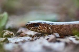
Great Crested Newt (GCN) Surveys & eDNA Testing in West Yorkshire
Need planning-compliant Great Crested Newt (GCN) surveys in West Yorkshire?
Our team provides targeted GCN services, including Natural England–approved eDNA assessments, delivering clear, practical reports to support planning applications and keep your development on schedule.
Fast, Clear, Planning-Ready Support
Fast response
Calls answered in 2 rings, emails replied to within the hour.
Free expert advice
Clear guidance before you commit.
Cost-effective
Working in partnership with clients to ensure planning approval first time
Typical 10-day turnaround
Industry Leading Standard
Expert Team
We stay with you from first call through to submission.
Do you need a GCN survey or eDNA test in West Yorkshire?
West Yorkshire’s landscape of canal-side ponds, industrial basins, park lakes, wet meadows, drainage ditches, and connected woodland edges provides suitable habitat for Great Crested Newts. Planning officers often require surveys where development may impact these habitats.
A GCN assessment identifies potential newt habitat, evaluates the risk to your project, and determines whether eDNA testing or full presence/absence surveys are needed, helping keep your development on track and avoiding seasonal delays.
You may require a Great Crested Newt (GCN) or eDNA survey in West Yorkshire if your project involves:
Development near ponds, such as canal-side ponds in Wakefield
Redevelopment or farm works around Huddersfield
Projects near wet meadows, woodlands, or hedgerows, like wet pasture and connected hedgerow networks in the Calder Valley
Landscaping affecting park lakes, drainage ditches, or industrial basins, such as ornamental lakes in Leeds or ditches near Bradford
Sites flagged as high GCN potential in areas like the South Pennines
Works during the April–June survey season, e.g., small ponds on properties near Halifax
Checking your West Yorkshire site postcode or location early helps determine whether a survey is needed and keeps your project on schedule.
We deliver Great Crested Newt (GCN) surveys across West Yorkshire, including Leeds, Bradford, Wakefield, Huddersfield, Halifax, Huddersfield, Dewsbury, Keighley, and surrounding towns and villages across the Calder Valley and South Pennines.
Why Planning Officers in Derbyshire Request GCN Assessments
In West Yorkshire, local planning authorities may request Great Crested Newt (GCN) survey evidence where suitable habitats—such as ponds, wet ditches, woodland edges, species-rich grassland, brownfield sites, and other connected terrestrial areas—are present, to ensure development proposals comply with wildlife legislation and national planning policy. Without timely and proportionate survey work, planning applications can be delayed due to validation queries, additional planning conditions, or seasonal restrictions linked to key GCN activity periods. These delays can disrupt project timelines and may lead to avoidable redesigns, highlighting the importance of early, targeted GCN assessments.
Local Case Insight
How GCN assessments work
We provide practical, proportionate GCN assessments, from habitat appraisals and eDNA or full surveys to clear, planning-ready reports with mitigation, timing guidance, and actionable next steps to keep projects on track.
Key Deliverables for West Yorkshire projects:
We provide planning-compliant Great Crested Newt (GCN) surveys across West Yorkshire, offering practical support for your project team, including:
Natural England–approved eDNA assessments
Full presence/absence surveys where required
Terrestrial habitat evaluations
Proportionate reporting to meet local planning authority requirements
Our approach is simple and effective: the right survey method at the correct stage, with clear, actionable guidance to keep your development on schedule.
Step 1
Schedule
Share your site details and programme, and we’ll identify whether an eDNA or full survey is required.
Step 2
Fieldwork
We conduct walkovers, eDNA tests, or full GCN surveys based on site potential and season.
Step 3
Reporting
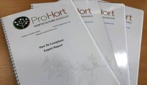
You receive planning-ready reports with impacts, mitigation, licensing, and clear timelines.
Next Steps
Require a GCN assessment in West Yorkshire? Check your site’s needs early to keep your project moving.
FAQ - GCN Surveys in West Yorkshire
Why might my development in West Yorkshire need a Great Crested Newt survey?
A Great Crested Newt survey may be required if your development could affect ponds or surrounding habitats capable of supporting this protected species. Across West Yorkshire, developments ranging from housing schemes to commercial developments and infrastructure projects may require ecological surveys where protected species are a planning consideration. Completing surveys early helps reduce the risk of delays during the planning process.
Are Great Crested Newts found in urban areas of West Yorkshire?
Yes. Great Crested Newts are not confined to rural locations. They can occupy suitable habitats within towns and cities, including country parks, sustainable drainage ponds, former industrial land, woodland edges and green corridors. Urban development sites should therefore be assessed individually rather than assuming protected species are absent.
Do planning authorities in West Yorkshire require ecological evidence before granting permission?
Where there is potential for Great Crested Newts to be affected, Local Planning Authorities may request ecological survey information before determining a planning application. Providing suitable survey evidence allows planners to consider protected species alongside the proposed development and helps avoid requests for additional information later in the application process.
Can a Great Crested Newt survey influence the design of my development?
Yes. Identifying ecological constraints at an early stage allows developers and designers to consider changes that avoid or reduce impacts on protected species. In some cases, relatively minor amendments to layouts, access routes or landscaping can reduce ecological impacts and simplify the planning process.
What survey methods are used to check for Great Crested Newts?
The survey method depends on the characteristics of the site and planning requirements. An ecologist may recommend an eDNA survey using pond water samples or traditional survey techniques carried out during the breeding season. The chosen approach will provide the information needed to support planning decisions and determine whether any further ecological work is required.
Can Great Crested Newt surveys help avoid unexpected project costs?
Yes. Identifying ecological constraints before construction begins enables developers to plan for any necessary mitigation, licensing or design changes. This proactive approach often reduces the likelihood of unexpected costs, programme delays or planning complications arising later in the project.
What happens after my Great Crested Newt survey has been completed?
Once the survey has been completed, your ecologist will prepare a report explaining the survey findings and their implications for the proposed development. Where no Great Crested Newts are identified, the report may satisfy planning requirements. If they are present, recommendations for mitigation or licensing will be included to support the planning process.
Can Great Crested Newts return to a pond after development has finished?
Yes. Where suitable habitat is retained or enhanced, Great Crested Newts can continue using breeding ponds and surrounding terrestrial habitats after development. Well planned mitigation and habitat management are often designed to maintain or improve conditions for the species alongside completed developments.
Which planning authorities in West Yorkshire may request a Great Crested Newt survey?
Great Crested Newt surveys may be requested by Leeds City Council, Bradford Metropolitan District Council, Calderdale Council, Kirklees Council or Wakefield Council, depending on the location of the proposed development. Applicants should review the ecological validation requirements published by the relevant Local Planning Authority before submitting a planning application.
Why choose ProHort for Great Crested Newt surveys in West Yorkshire?
ProHort provides Great Crested Newt surveys throughout West Yorkshire for homeowners, developers, architects, planning consultants and commercial organisations. Our experienced ecologists deliver practical ecological advice, recognised survey methodologies and detailed planning reports that meet Local Planning Authority requirements. By identifying ecological issues at the earliest opportunity, we help clients minimise planning risks and keep developments progressing efficiently.