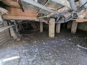
Tree Damage Survey in Hampshire

Tree Damage Surveys in Hampshire

Has tree-related damage raised concerns about safety or responsibility in Hampshire?

We deliver independent arboricultural evidence that clarifies causation, risk and next steps so decisions can be made calmly, fairly and without escalation.

Request a Tree Damage Survey

Request a Tree Damage Survey

Maximum file size: 8.39MB

Fast, Clear, Planning-Ready Support

Fast response 

Calls answered in 2 rings, emails replied to within the hour.

Free expert advice

Clear guidance before you commit.

Cost-effective

Working in partnership with clients to ensure planning approval first time

Typical 10-day turnaround

Industry Leading Standard

Expert Team

We stay with you from first call through to submission. 

Do you need a Tree Damage Survey in Hampshire?

If you’ve noticed cracking, distortion, lifting or unexplained movement to a building, driveway or retaining structure, a tree damage survey helps establish whether nearby trees are contributing to the issue or whether the cause lies elsewhere.

For homeowners, this often supports insurance discussions or peace of mind before repairs. For developers and landlords, it provides clarity before remedial works, claims or planning decisions escalate.

Early assessment prevents misdiagnosis, unnecessary tree loss and prolonged uncertainty.

Across Hampshire, tree damage concerns often arise where clay soils, historic estates, and modern housing developments intersect. This is frequently seen on:

  • Established residential plots in towns such as Winchester, Basingstoke, Southampton and Portsmouth, where mature trees sit close to dwellings, garages, or extensions

  • Edge-of-settlement developments around Andover and Eastleigh, where retained trees influence driveway layouts, service routes, and underground utilities

  • Redevelopment plots with historic tree belts or former parkland

  • Semi-rural villages where tree groups sit near foundations, walls, or drainage systems, increasing long-term movement risk

Cracking, heave, root intrusion, or structural movement often triggers the need for independent arboricultural assessment to guide repairs and insurance decisions.

Our Tree Damage Surveys serve Winchester, Basingstoke, Southampton, Portsmouth, Andover, Eastleigh and surrounding areas

Why Hampshire Authorities and Insurers Request Tree Damage Surveys

Hampshire planning authorities rely on clear arboricultural evidence where trees are alleged to have caused structural damage or where liability, safety or future risk is disputed. Damage assessments are often requested to inform planning decisions, neighbour disputes, insurance claims or remediation strategies. Reports must align with BS 5837 where development is involved and BS 3998 (Tree Work) where management or remedial works are proposed, alongside the Town and Country Planning Act 1990 where protected trees or planning conditions apply. Where evidence is unclear, matters frequently stall.

Clear, proportionate arboricultural reporting allows damage risk to be assessed objectively, avoiding speculative conclusions and unnecessary restriction.

Local Case Insight

A homeowner in Winchester reported cracking along a rear extension near a mature oak and sycamore group. Insurers initially suspected root-related subsidence. Our survey assessed tree health, root extent, soil composition, and foundation type, confirming that seasonal soil shrinkage was the primary driver. Targeted repair guidance allowed building work to proceed without tree removal and provided clear, technical evidence for insurers, helping avoid unnecessary disputes and ensuring the trees remained protected.

The Process - Tree Damage Surveys

Our Tree Damage Surveys in Hampshire provide clear, defensible evidence that insurers, engineers and local authorities can rely on – avoiding delay, dispute or unnecessary tree removal.

Key Deliverables for Tree Damage Surveys in Hampshire

We provide a planning and insurance focused service for your Hampshire site. This typically includes:

  • Clear identification of whether trees are contributing to damage

  • Proportionate management or monitoring recommendations

  • Reporting suitable for insurers, engineers or planning records

  • Guidance aligned with local soil and development conditions

Where appropriate, findings can integrate with Tree Health Surveys, Subsidence Reports or TPO advice.

Step 1

Initial
Review

Review of site location, damage history and surrounding tree context.

Step 2

On-site
Assessment

Visual inspection of trees, structures and ground conditions.

Step 3

Evidence-led
Analysis

Assessment of proximity, species behaviour, soil conditions and likely interaction.

Step 4

Clear
Reporting

Integration into subsidence or health assessments where needed.

Next Steps

Concerned about tree damage in Hampshire?


We’ll confirm the cause, clarify the risk and help you move forward with confidence.

FAQ - Tree Damage Surveys in Hampshire

When is a tree damage survey typically required in Hampshire?

In Hampshire, a tree damage survey is often required where properties are located close to mature trees within gardens, boundaries, or nearby land. This is common in both established residential areas and village settings where trees have been retained over time. Surveys are usually prompted by visible cracking, structural movement, or concerns raised during property ownership or planned development.

Hampshire includes a range of ground conditions, from clay soils to lighter coastal and chalk based areas. These variations can influence how the ground behaves around buildings. A tree damage survey considers these local factors alongside tree species and location to determine whether trees are contributing to structural issues.

Trees can contribute to cracking in walls, movement in boundary structures, lifting of paving, and displacement of driveways or patios. In Hampshire, where many properties feature mature landscaping, these interactions can develop gradually and require careful assessment.

A tree damage survey assesses the pattern and form of damage, the species and size of nearby trees, their proximity to structures, and the surrounding site conditions. This allows a professional conclusion to be reached on whether tree involvement is likely, possible, or unlikely.

Yes. In Hampshire, where properties may be separated by gardens, hedgerows, or open land, concerns about neighbouring trees can arise. A tree damage survey provides an evidence based assessment to help determine whether a specific tree is contributing to the issue before discussions around responsibility take place.

Do you need permission to carry out work to trees in Hampshire?

In many cases, yes. Trees may be protected by Tree Preservation Orders or located within conservation areas. Guidance can be found through local authorities such as Hampshire County Council:
https://www.hants.gov.uk/landplanningandenvironment/trees

A tree damage survey can support applications by providing technical justification where works are required.

The survey includes inspection of the damage, identification and assessment of nearby trees, evaluation of their proximity to structures, and consideration of likely root behaviour and site conditions. In Hampshire, particular attention may be given to varying soil conditions, drainage, and the relationship between buildings and surrounding landscape.

Yes. Identifying whether trees are contributing to damage before carrying out repairs or development is essential. Without this understanding, the underlying issue may remain unresolved. A tree damage survey helps ensure that any works are appropriate and based on evidence.

Not always. Removing a tree without understanding the cause of damage can lead to further movement or fail to resolve the issue. A tree damage survey considers both the current situation and the potential impact of any proposed works, ensuring that decisions are balanced and appropriate.

Following the survey, a detailed report outlines the findings and recommendations. This may include monitoring, repair planning, or applications for tree works where protection applies. The report can also support discussions with neighbours, local authorities, or other professionals, ensuring decisions are based on clear and structured advice.

Related Services

Tree Damage Survey in Essex

Tree Damage Surveys in Essex

Has tree-related damage raised concerns about safety or responsibility in Essex?

We deliver independent arboricultural evidence that clarifies causation, risk and next steps so decisions can be made calmly, fairly and without escalation.

Request a Tree Damage Survey

Request a Tree Damage Survey

Maximum file size: 8.39MB

Fast, Clear, Planning-Ready Support

Fast response 

Calls answered in 2 rings, emails replied to within the hour.

Free expert advice

Clear guidance before you commit.

Cost-effective

Working in partnership with clients to ensure planning approval first time

Typical 10-day turnaround

Industry Leading Standard

Expert Team

We stay with you from first call through to submission. 

Do you need a Tree Damage Survey in Essex?

If you’ve noticed cracking, distortion, lifting or unexplained movement to a building, driveway or retaining structure, a tree damage survey helps establish whether nearby trees are contributing to the issue or whether the cause lies elsewhere.

For homeowners, this often supports insurance discussions or peace of mind before repairs. For developers and landlords, it provides clarity before remedial works, claims or planning decisions escalate.

Early assessment prevents misdiagnosis, unnecessary tree loss and prolonged uncertainty.

Across Essex, tree damage concerns most often arise where suburban development, clay soils, and mature trees coexist. Retained trees can impact foundations, drainage, and garden layouts, especially in areas with older housing or post-war extensions.

This is particularly common on:

  • Established residential plots in towns such as Chelmsford, Colchester, Basildon and Southend-on-Sea, where mature boundary trees sit near dwellings, garages, or extensions

  • Edge-of-settlement developments around Harlow and Brentwood, where retained trees influence driveway layouts, access routes, and underground services

  • Redevelopment sites with historic tree belts or former agricultural land

  • Semi-rural villages where tree groups sit close to walls, foundations, or drainage systems

Visible cracking, heave, root intrusion, or seasonal movement often necessitates professional arboricultural evidence.

Our Tree Damage Surveys serve Chelmsford, Colchester, Basildon, Southend-on-Sea, Harlow, Brentwood and surrounding areas

Why Essex Authorities and Insurers Request Tree Damage Surveys

Essex planning authorities rely on clear arboricultural evidence where trees are alleged to have caused structural damage or where liability, safety or future risk is disputed. Damage assessments are often requested to inform planning decisions, neighbour disputes, insurance claims or remediation strategies. Reports must align with BS 5837 where development is involved and BS 3998 (Tree Work) where management or remedial works are proposed, alongside the Town and Country Planning Act 1990 where protected trees or planning conditions apply. Where evidence is unclear, matters frequently stall.

Clear, proportionate arboricultural reporting allows damage risk to be assessed objectively, avoiding speculative conclusions and unnecessary restriction.

Local Case Insight

A homeowner in Colchester noticed cracking along a single-storey extension near a mature sycamore. Insurers initially raised concerns over root damage. Our detailed survey assessed tree health, root patterns, and soil moisture variation, confirming that seasonal clay movement was the primary factor. Recommendations allowed repairs to proceed while retaining the tree, with clear supporting evidence for insurers and minimal disruption to the property.

The Process - Tree Damage Surveys

Our Tree Damage Surveys in Essex provide clear, defensible evidence that insurers, engineers and local authorities can rely on – avoiding delay, dispute or unnecessary tree removal.

Key Deliverables for Tree Damage Surveys in Essex

We provide a planning and insurance focused service for your Essex site. This typically includes:

  • Clear identification of whether trees are contributing to damage

  • Proportionate management or monitoring recommendations

  • Reporting suitable for insurers, engineers or planning records

  • Guidance aligned with local soil and development conditions

Where appropriate, findings can integrate with Tree Health Surveys, Subsidence Reports or TPO advice.

Step 1

Initial
Review

Review of site location, damage history and surrounding tree context.

Step 2

On-site
Assessment

Visual inspection of trees, structures and ground conditions.

Step 3

Evidence-led
Analysis

Assessment of proximity, species behaviour, soil conditions and likely interaction.

Step 4

Clear
Reporting

Integration into subsidence or health assessments where needed.

Next Steps

Concerned about tree damage in Essex?


We’ll confirm the cause, clarify the risk and help you move forward with confidence.

FAQ - Tree Damage Surveys in Essex

When is a tree damage survey typically required in Essex?

In Essex, a tree damage survey is often required where properties are located close to mature trees within residential areas, garden boundaries, or development sites. This is particularly common where visible cracking, structural movement, or ground changes are observed, especially in areas with established planting and limited space between trees and buildings.

Parts of Essex are known for clay soils, which can respond to changes in moisture levels. Trees can influence this by drawing water from the ground, potentially contributing to movement around structures. A tree damage survey considers these soil conditions alongside tree species and location to assess whether trees are a contributing factor.

Trees can contribute to cracking in walls, movement in boundary structures, lifting of paving, and displacement of driveways or patios. In Essex, where properties often feature landscaped gardens and retained trees, these interactions can develop over time and require careful assessment.

A tree damage survey assesses the pattern and form of damage, the species and size of nearby trees, their proximity to structures, and the surrounding site conditions. This allows a professional conclusion to be reached on whether tree involvement is likely, possible, or unlikely.

Yes. In Essex, where properties may be closely spaced or separated by gardens and boundaries, concerns about neighbouring trees can arise. A tree damage survey provides an evidence based assessment to help determine whether a specific tree is contributing to the issue before discussions around responsibility take place.

Do you need permission to carry out work to trees in Essex?

In many cases, yes. Trees may be protected by Tree Preservation Orders or located within conservation areas. Guidance can be found through local authorities such as Essex County Council:
https://www.essex.gov.uk/planning-advice/trees

A tree damage survey can support applications by providing technical justification where works are required.

The survey includes inspection of the damage, identification and assessment of nearby trees, evaluation of their proximity to structures, and consideration of likely root behaviour and site conditions. In Essex, particular attention is often given to soil type, drainage, and the relationship between trees and residential development.

Yes. Identifying whether trees are contributing to damage before carrying out repairs or development is essential. Without this understanding, the underlying issue may remain unresolved. A tree damage survey helps ensure that any works are appropriate and based on evidence.

Not always. Removing a tree without understanding the cause of damage can lead to further movement or fail to resolve the issue. A tree damage survey considers both the current situation and the potential impact of any proposed works, ensuring that decisions are balanced and appropriate.

Following the survey, a detailed report outlines the findings and recommendations. This may include monitoring, repair planning, or applications for tree works where protection applies. The report can also support discussions with neighbours, local authorities, or other professionals, ensuring decisions are based on clear and structured advice.
Related Services

Tree Damage Survey in Merseyside

Tree Damage Surveys in Merseyside

Has tree-related damage raised concerns about safety or responsibility in Merseyside?

We deliver independent arboricultural evidence that clarifies causation, risk and next steps so decisions can be made calmly, fairly and without escalation. 

Request a Tree Damage Survey

Request a Tree Damage Survey

Maximum file size: 8.39MB

Fast, Clear, Planning-Ready Support

Fast response 

Calls answered in 2 rings, emails replied to within the hour.

Free expert advice

Clear guidance before you commit.

Cost-effective

Working in partnership with clients to ensure planning approval first time

Typical 10-day turnaround

Industry Leading Standard

Expert Team

We stay with you from first call through to submission. 

Do you need a Tree Damage Survey in Merseyside?

If you’ve noticed cracking, distortion, lifting or unexplained movement to a building, driveway or retaining structure, a tree damage survey helps establish whether nearby trees are contributing to the issue or whether the cause lies elsewhere.

For homeowners, this often supports insurance discussions or peace of mind before repairs. For developers and landlords, it provides clarity before remedial works, claims or planning decisions escalate.

Early assessment prevents misdiagnosis, unnecessary tree loss and prolonged uncertainty.

Across Merseyside, tree damage concerns often arise where older urban housing, clay soils, and mature trees coexist. Retained trees can influence foundations, walls, drainage systems, and even driveway layouts, particularly in semi-rural or densely developed plots.

This is particularly common on:

  • Established residential plots in Liverpool, St Helens, Wirral and Southport, where large boundary trees sit close to dwellings or extensions

  • Edge-of-settlement developments around Bootle and Birkenhead, where retained trees influence driveway layouts, parking, or underground utilities

  • Redevelopment plots incorporating historic tree belts

  • Semi-rural properties and village plots where tree groups sit near foundations, walls, or drainage runs

Visible cracking, heave, root intrusion, or structural movement often necessitates professional arboricultural assessment to guide remedial work.

Our Tree Damage Surveys serve Liverpool, St Helens, Wirral, Southport, Bootle, Birkenhead and surrounding areas

Why Merseyside Authorities and Insurers Request Tree Damage Surveys

Merseyside planning authorities rely on clear arboricultural evidence where trees are alleged to have caused structural damage or where liability, safety or future risk is disputed. Damage assessments are often requested to inform planning decisions, neighbour disputes, insurance claims or remediation strategies. Reports must align with BS 5837 where development is involved and BS 3998 (Tree Work) where management or remedial works are proposed, alongside the Town and Country Planning Act 1990 where protected trees or planning conditions apply. Where evidence is unclear, matters frequently stall.

Clear, proportionate arboricultural reporting allows damage risk to be assessed objectively, avoiding speculative conclusions and unnecessary restriction.

Local Case Insight

A homeowner in Liverpool observed cracking near a rear extension adjacent to a mature oak. Insurers suspected possible root damage. Our survey evaluated tree condition, root patterns, and soil composition, confirming that seasonal clay shrinkage was the dominant factor. Recommendations allowed repairs to proceed without removing the tree, giving insurers clear supporting evidence and ensuring the tree’s long-term health.

The Process - Tree Damage Surveys

Our Tree Damage Surveys in Merseyside provide clear, defensible evidence that insurers, engineers and local authorities can rely on – avoiding delay, dispute or unnecessary tree removal.

Key Deliverables for Tree Damage Surveys in Merseyside

We provide a planning and insurance focused service for your Merseyside site. This typically includes:

  • Clear identification of whether trees are contributing to damage

  • Proportionate management or monitoring recommendations

  • Reporting suitable for insurers, engineers or planning records

  • Guidance aligned with local soil and development conditions

Where appropriate, findings can integrate with Tree Health Surveys, Subsidence Reports or TPO advice.

Step 1

Initial
Review

Review of site location, damage history and surrounding tree context.

Step 2

On-site
Assessment

Visual inspection of trees, structures and ground conditions.

Step 3

Evidence-led
Analysis

Assessment of proximity, species behaviour, soil conditions and likely interaction.

Step 4

Clear
Reporting

Integration into subsidence or health assessments where needed.

Next Steps

Concerned about tree damage in Merseyside?


We’ll confirm the cause, clarify the risk and help you move forward with confidence.

FAQ - Tree Damage Surveys in Merseyside

When is a tree damage survey typically required in Merseyside?

In Merseyside, a tree damage survey is often required where properties are located close to mature trees within dense urban areas, housing estates, or regeneration sites. This is particularly common where space is limited and trees sit close to buildings, roads, or boundary structures. Surveys are usually prompted by visible cracking, movement, or concerns raised during property ownership or development.

Merseyside includes a mix of urban environments, older housing stock, and coastal influences. Trees are often planted within constrained spaces, which can affect how roots develop and interact with nearby structures. A tree damage survey helps determine whether these interactions are contributing to damage or whether other factors are involved.

Trees can contribute to cracking in walls, movement in boundary features, lifting of paving, and displacement of driveways or footpaths. In Merseyside, where properties are often closely spaced, even relatively small distances between trees and structures can become significant.

Yes. In Merseyside, where redevelopment and regeneration are common, a tree damage survey can help identify whether existing trees may affect structures or whether damage risks need to be addressed before work begins. This is particularly important where trees are to be retained as part of a scheme.

A tree damage survey assesses the pattern and form of damage, the species and size of nearby trees, their proximity to structures, and the surrounding site conditions. This allows a professional conclusion to be reached on whether tree involvement is likely, possible, or unlikely.

Do you need permission to carry out work to trees in Merseyside?

In many cases, yes. Trees may be protected by Tree Preservation Orders or located within conservation areas. Guidance can be found through local authorities such as Liverpool City Council:
https://liverpool.gov.uk/parks-and-green-spaces/trees-and-woodland/

A tree damage survey can support applications by providing technical justification where works are required.

The survey includes inspection of the damage, identification and assessment of nearby trees, evaluation of their proximity to structures, and consideration of likely root behaviour and site conditions. In Merseyside, particular attention is often given to constrained urban sites, shared boundaries, and underground infrastructure.

Yes. Identifying whether trees are contributing to damage before carrying out repairs or alterations is essential. Without this understanding, the underlying issue may remain unresolved. A tree damage survey helps ensure that any works are appropriate and based on evidence.

Not always. Removing a tree without understanding the cause of damage can lead to further movement or fail to resolve the issue. A tree damage survey considers both the current situation and the potential impact of any proposed works, ensuring that decisions are balanced and appropriate.

Following the survey, a detailed report outlines the findings and recommendations. This may include monitoring, repair planning, or applications for tree works where protection applies. The report can also support discussions with neighbours, local authorities, or other professionals, ensuring decisions are based on clear and structured advice.

Related Services

Tree Damage Survey in Kent

Tree Damage Surveys in Kent

Has tree-related damage raised concerns about safety or responsibility in Kent?

We deliver independent arboricultural evidence that clarifies causation, risk and next steps so decisions can be made calmly, fairly and without escalation. 

Request a Tree Damage Survey

Request a Tree Damage Survey

Maximum file size: 8.39MB

Fast, Clear, Planning-Ready Support

Fast response 

Calls answered in 2 rings, emails replied to within the hour.

Free expert advice

Clear guidance before you commit.

Cost-effective

Working in partnership with clients to ensure planning approval first time

Typical 10-day turnaround

Industry Leading Standard

Expert Team

We stay with you from first call through to submission. 

Do you need a Tree Damage Survey in Kent?

If you’ve noticed cracking, distortion, lifting or unexplained movement to a building, driveway or retaining structure, a tree damage survey helps establish whether nearby trees are contributing to the issue or whether the cause lies elsewhere.

For homeowners, this often supports insurance discussions or peace of mind before repairs. For developers and landlords, it provides clarity before remedial works, claims or planning decisions escalate.

Early assessment prevents misdiagnosis, unnecessary tree loss and prolonged uncertainty.

Across Kent, tree damage concerns most often arise where historic housing, clay soils, and mature trees intersect. Retained trees can influence foundations, walls, drainage, and landscaping, particularly on older properties or semi-rural plots.

This is frequently seen on:

  • Established residential plots in towns such as Maidstone, Canterbury, Tonbridge and Tunbridge Wells, where mature boundary trees sit close to dwellings, garages, or extensions

  • Edge-of-settlement developments around Sevenoaks and Ashford, where retained trees affect driveway layouts, access, or underground utilities

  • Redevelopment plots incorporating historic tree belts, former parkland, or agricultural land

  • Semi-rural villages and countryside properties where tree groups sit near walls, foundations, or drainage systems

Cracking, heave, root intrusion, or movement often necessitates independent arboricultural assessment to guide building repairs and insurance decisions.

Our Tree Damage Surveys serve Maidstone, Canterbury, Tonbridge, Tunbridge Wells, Sevenoaks, Ashford and surrounding areas

Why Kent Authorities and Insurers Request Tree Damage Surveys

Kent planning authorities rely on clear arboricultural evidence where trees are alleged to have caused structural damage or where liability, safety or future risk is disputed. Damage assessments are often requested to inform planning decisions, neighbour disputes, insurance claims or remediation strategies. Reports must align with BS 5837 where development is involved and BS 3998 (Tree Work) where management or remedial works are proposed, alongside the Town and Country Planning Act 1990 where protected trees or planning conditions apply. Where evidence is unclear, matters frequently stall.

Clear, proportionate arboricultural reporting allows damage risk to be assessed objectively, avoiding speculative conclusions and unnecessary restriction.

Local Case Insight

A homeowner in Tonbridge reported progressive cracking along a rear extension near a mature beech and maple group. Insurers were concerned that root action could be responsible. Our detailed survey assessed tree health, root extent, soil shrinkage patterns, and foundation type, confirming seasonal soil movement as the main factor. Recommendations enabled targeted repairs without tree removal, ensured long-term structural stability, and provided insurers with clear, technical evidence to support claims.

The Process - Tree Damage Surveys

Our Tree Damage Surveys in Kent provide clear, defensible evidence that insurers, engineers and local authorities can rely on – avoiding delay, dispute or unnecessary tree removal.

Key Deliverables for Tree Damage Surveys in Kent

We provide a planning and insurance focused service for your Kent site. This typically includes:

  • Clear identification of whether trees are contributing to damage

  • Proportionate management or monitoring recommendations

  • Reporting suitable for insurers, engineers or planning records

  • Guidance aligned with local soil and development conditions

Where appropriate, findings can integrate with Tree Health Surveys, Subsidence Reports or TPO advice.

Step 1

Initial
Review

Review of site location, damage history and surrounding tree context.

Step 2

On-site
Assessment

Visual inspection of trees, structures and ground conditions.

Step 3

Evidence-led
Analysis

Assessment of proximity, species behaviour, soil conditions and likely interaction.

Step 4

Clear
Reporting

Integration into subsidence or health assessments where needed.

Next Steps

Concerned about tree damage in Kent?


We’ll confirm the cause, clarify the risk and help you move forward with confidence.

FAQ - Tree Damage Surveys in Kent

When is a tree damage survey typically required in Kent?

In Kent, a tree damage survey is often required where properties are located close to mature trees within gardens, boundaries, or development sites. This is particularly common in established residential areas and village settings where trees have been retained over time. Surveys are usually prompted by visible cracking, structural movement, or concerns raised during property ownership or planned works.

Kent includes a mix of clay soils, chalk landscapes, and coastal conditions, all of which can influence how the ground behaves around buildings. Trees can interact with these conditions through moisture demand and root growth. A tree damage survey considers these local factors to determine whether trees are contributing to structural issues.

Trees can contribute to cracking in walls, movement in boundary structures, lifting of paving, and displacement of driveways or patios. In Kent, where many properties have well established gardens and mature planting, these interactions can develop gradually and require careful assessment.

A tree damage survey assesses the pattern and form of damage, the species and size of nearby trees, their proximity to structures, and the surrounding site conditions. This allows a professional conclusion to be reached on whether tree involvement is likely, possible, or unlikely.

Yes. In Kent, where properties may be separated by gardens, hedgerows, or boundaries, concerns about neighbouring trees can arise. A tree damage survey provides an evidence based assessment to help determine whether a specific tree is contributing to the issue before discussions around responsibility take place.

Do you need permission to carry out work to trees in Kent?

In many cases, yes. Trees may be protected by Tree Preservation Orders or located within conservation areas. Guidance can be found through local authorities such as Kent County Council:
https://www.kent.gov.uk/environment-waste-and-planning/trees

A tree damage survey can support applications by providing technical justification where works are required.

The survey includes inspection of the damage, identification and assessment of nearby trees, evaluation of their proximity to structures, and consideration of likely root behaviour and site conditions. In Kent, particular attention is often given to soil conditions, drainage, and the relationship between trees and residential development.

Yes. Identifying whether trees are contributing to damage before carrying out repairs or development is essential. Without this understanding, the underlying issue may remain unresolved. A tree damage survey helps ensure that any works are appropriate and based on evidence.

Not always. Removing a tree without understanding the cause of damage can lead to further movement or fail to resolve the issue. A tree damage survey considers both the current situation and the potential impact of any proposed works, ensuring that decisions are balanced and appropriate.

Following the survey, a detailed report outlines the findings and recommendations. This may include monitoring, repair planning, or applications for tree works where protection applies. The report can also support discussions with neighbours, local authorities, or other professionals, ensuring decisions are based on clear and structured advice.

Related Services

Environmental Impact Assessment (EIA) in Nottinghamshire

Environmental Impact Assessment (EIA) in Nottinghamshire

Will ecology slow down your Nottinghamshire development? 

An EIA maintains project control before planning pressure builds. 

Request an Environmental Impact Assessment

Request an Environmental Impact Assessment

Maximum file size: 8.39MB

Fast, Clear, Planning-Ready Support

Fast response 

Calls answered in 2 rings, emails replied to within the hour.

Free expert advice

Clear guidance before you commit.

Cost-effective

Working in partnership with clients to ensure planning approval first time

Typical 10-day turnaround

Industry Leading Standard

Expert Team

We stay with you from first call through to submission. 

Do you need an EIA in Nottinghamshire?

If your development could significantly affect land, wildlife, water, or landscapes, the council will expect formal ecological evidence in Nottinghamshire before it can be approved. Environmental Impact Assessments (EIA) in Nottinghamshire span to major housing, infrastructure, commercial and mixed-use developments. 

Where an EIA applies, a planning application in Nottinghamshire cannot progress without a legally compliant ecology assessment in place.

Nottinghamshire’s landscape contains several features that frequently elevate EIA risk:

• Trent Valley and Sherwood fringe near Newark and Southwell — riparian habitats and wet grassland amplify cumulative hydrological and ecological impact concerns
• Sherwood Forest and adjacent heathland blocks — designated landscapes and bat commuting corridors linked to ancient woodland connectivity

• Former collieries and industrial estates in Mansfield, Hucknall and Worksop — diverse brownfield mosaics and legacy contamination elevate assessment complexity

• Trent & Mersey and Chesterfield Canal corridors — linear movement routes for protected species intersect with proposed infrastructure upgrades

• Agricultural edges around Bingham and Retford — hedgerow networks, ponds and traditional field boundaries highlight protected species dependency

These factors commonly influence EIA screening and scoping decisions.

Our Environmental Impact Assessment services support all Nottinghamshire Local Planning Authorities, delivering precise ecological data to ensure seamless application processing and regulatory compliance.

Why Planning Authorities Request an EIA in Nottinghamshire

Nottinghamshire local planning authorities (LPA) are obligated to consider the Wildlife & Countryside Act 1981, the Habitats Regulations, and the NERC Act 2006 in their decision-making process. LPAs use an Environmental Impact Assessment (EIA)  to provide a comprehensive evaluation of all potential environmental impacts. These include ecological risks, such as evaluating protected species in Nottinghamshire projects, to ensure a holistic understanding of a project’s implications.

Without a detailed EIA in Nottinghamshire, applications risk delays due to incomplete environmental assessments, seasonal survey requirements, or additional conditions pending further evidence to address ecological concerns.

Local Case Insight

A logistics upgrade on the outskirts of Newark, close to the Trent floodplain, was originally submitted for screening without full environmental assessment. In pre-application discussions, the council flagged potential effects on river corridor habitats and interaction with nearby industrial expansion. A full environmental assessment was undertaken to examine floodplain alteration, habitat disturbance and construction-phase impacts. This enabled statutory consultees to respond with confidence and informed proportionate mitigation conditions at determination. The scheme passed through planning committee efficiently, avoiding deferral or major objection.

What Happens During an Environmental Impact Assessment (EIA) in Nottinghamshire?

Environmental Impact Assessments (EIA) in Nottinghamshire must be precise, proportionate and defensible under challenge. We scope tightly to legal triggers, match survey effort to real risk, and structure reporting so that planning officers, consultees and inspectors can rely on it without hesitation. 

Key Deliverables for Nottinghamshire EIA Projects

Our EIA meets the evidence requirements set by Nottinghamshire Local Planning Authorities and delivers:

  • Full environmental assessment chapter suitable for planning submission and public consultation 
  • Site-specific baseline surveys and clear impact findings 
  • Practical mitigation and monitoring strategy that planners can condition and discharge 
  • Integrated reporting aligned with highways, drainage, landscape and BNG where required 

All evidence is prepared for legal scrutiny, committee reporting and public consultation in Nottinghamshire. 

Step 1

Screening & Scoping

Review of proposal, screening opinion and environmental sensitivities to define ecology scope. 

Step 2

Baseline Surveys

Targeted habitat and species surveys using nationwide methods consistent with CIEEM and Natural England. 

Step 3

Impact Assessment

Construction and operational effects evaluated with clear significance reasoning. 

Step 4

Reporting & Integration

Policy-linked ecology chapter ready for submission within the Environmental Statement. 

Next Steps

Need an EIA in Nottinghamshire?


We’ll assess your site’s requirements and outline the most efficient path to compliance.

FAQ - Environmental Impact Assessments (EIA) in Nottinghamshire

What is the purpose of an Environmental Impact Assessment?

The purpose of an Environmental Impact Assessment is to identify, predict, and evaluate the environmental effects of a proposed development before planning permission is determined. In Nottinghamshire, it helps ensure that environmental considerations are fully integrated into the decision making process and that any significant impacts are properly addressed.

EIA is typically required for developments that are large in scale or located in environmentally sensitive areas. This can include residential schemes, industrial developments, infrastructure projects, and certain rural developments. A screening opinion from the Local Planning Authority will confirm whether your project falls within EIA regulations.

The EIA process generally follows a structured sequence including screening, scoping, baseline data collection, impact assessment, mitigation design, and reporting. These stages ensure that all environmental effects are properly assessed and clearly presented within the planning application.

An Environmental Statement is the formal document submitted as part of an EIA. It brings together all technical assessments, explains the likely environmental impacts of the development, and sets out mitigation measures. In Nottinghamshire, this document is reviewed by the Local Planning Authority and statutory consultees during the planning process.

An Environmental Impact Assessment can include a range of environmental topics depending on the site and development. Common areas include ecology, air quality, noise, landscape and visual impact, transport, and water environment. The exact scope is agreed during the scoping stage.

How does an EIA support planning approval?

An EIA provides robust evidence to support a planning application by demonstrating that environmental impacts have been properly considered and mitigated. In Nottinghamshire, a well prepared Environmental Statement can reduce objections, address planning concerns early, and improve the likelihood of approval.

During scoping, the developer seeks agreement from the Local Planning Authority on which environmental topics need to be assessed. This ensures the assessment is proportionate and focused, avoiding unnecessary work while covering all key issues that could influence the planning decision.

An EIA is typically coordinated by environmental consultants who manage a team of specialists covering areas such as ecology, acoustics, air quality, and transport. A coordinated approach ensures that all technical inputs are aligned and that the final Environmental Statement is clear and robust.

EIA requests are handled by the relevant Local Planning Authority depending on the site location, which may include district or borough councils across the county, alongside
Nottinghamshire County Council
Planning guidance and services can be accessed via:
https://www.nottinghamshire.gov.uk/

Yes, an Environmental Impact Assessment not only identifies potential negative impacts but can also highlight opportunities to enhance biodiversity, improve landscape design, and create more sustainable developments. This can strengthen the overall planning proposal and align with current planning policy expectations.

Related Services

Still have questions?

Still have questions?

(EIA) Environmental Impact Assessment in Sussex

Environmental Impact Assessment (EIA) in Sussex

Will ecology slow down your Sussex development? 

An EIA maintains project control before planning pressure builds. 

Request a Preliminary Ecological Appraisal

Request a Preliminary Ecological Appraisal

Maximum file size: 8.39MB

Fast, Clear, Planning-Ready Support

Fast response 

Calls answered in 2 rings, emails replied to within the hour.

Free expert advice

Clear guidance before you commit.

Cost-effective

Working in partnership with clients to ensure planning approval first time

Typical 10-day turnaround

Industry Leading Standard

Expert Team

We stay with you from first call through to submission. 

Do you need an EIA in Sussex?

If your development could significantly affect land, wildlife, water, or landscapes, the council will expect formal ecological evidence in Sussex before it can be approved. Environmental Impact Assessments (EIA) in Sussex span to major housing, infrastructure, commercial and mixed-use developments. 

Where an EIA applies, a planning application in Sussex cannot progress without a legally compliant ecology assessment in place.

Sussex’s environmental character regularly drives EIA consideration:

• South Downs chalk landscapes from Lewes to Arundel — nationally protected habitats and landscape character constraints

• Coastal margins from Brighton to Shoreham and Chichester Harbour — sensitive intertidal zones and bird migration routes

• Historic agricultural holdings within the High Weald — ancient woodland fragments, veteran trees and species-rich grassland mosaics

• Arun, Adur and Ouse river corridors — riparian habitat continuity and flood dynamics
• Rural settlement fringes around Midhurst and Rye — hedgerow systems and pond networks increase protected species connectivity

These considerations are central to EIA screening outcomes.

Our Environmental Impact Assessment services support all Sussex Local Planning Authorities, delivering precise ecological data to ensure seamless application processing and regulatory compliance.

Why Planning Authorities Request an EIA in Sussex

Sussex local planning authorities (LPA) are obligated to consider the Wildlife & Countryside Act 1981, the Habitats Regulations, and the NERC Act 2006 in their decision-making process. LPAs use an Environmental Impact Assessment (EIA)  to provide a comprehensive evaluation of all potential environmental impacts. These include ecological risks, such as evaluating protected species in Sussex projects, to ensure a holistic understanding of a project’s implications.

Without a detailed EIA in Sussex, applications risk delays due to incomplete environmental assessments, seasonal survey requirements, or additional conditions pending further evidence to address ecological concerns.

Local Case Insight

A warehouse intensification project near Shoreham Harbour was submitted for screening without a detailed environmental report. The planning authority identified risks to coastal habitats and the cumulative influence of port-related development during early review. A comprehensive environmental assessment was commissioned, evaluating shoreline processes, ecological disturbance and construction effects. With clear evidence, statutory consultees provided targeted feedback, and mitigation was conditioned accordingly. The proposal advanced through committee without referral or contentious challenge.

What Happens During an Environmental Impact Assessment (EIA) in Sussex?

Environmental Impact Assessments (EIA) in Sussex must be precise, proportionate and defensible under challenge. We scope tightly to legal triggers, match survey effort to real risk, and structure reporting so that planning officers, consultees and inspectors can rely on it without hesitation. 

Key Deliverables for Sussex EIA Projects

Our EIA meets the evidence requirements set by Sussex Local Planning Authorities and delivers:

  • Full environmental assessment chapter suitable for planning submission and public consultation 
  • Site-specific baseline surveys and clear impact findings 
  • Practical mitigation and monitoring strategy that planners can condition and discharge 
  • Integrated reporting aligned with highways, drainage, landscape and BNG where required 

All evidence is prepared for legal scrutiny, committee reporting and public consultation in Sussex. 

Step 1

Screening & Scoping

Review of proposal, screening opinion and environmental sensitivities to define ecology scope. 

Step 2

Baseline Surveys

Targeted habitat and species surveys using nationwide methods consistent with CIEEM and Natural England. 

Step 3

Impact Assessment

Construction and operational effects evaluated with clear significance reasoning. 

Step 4

Reporting & Integration

Policy-linked ecology chapter ready for submission within the Environmental Statement. 

Next Steps

Need an EIA in Sussex?


We’ll assess your site’s requirements and outline the most efficient path to compliance.

FAQ - Environmental Impact Assessments (EIA) in Sussex

What determines whether a development requires an Environmental Impact Assessment in Sussex?

In Sussex, whether an Environmental Impact Assessment is required depends on the type, scale, and location of the development. Projects that fall under Schedule 1 automatically require EIA, while Schedule 2 developments are assessed on a case by case basis. Developments in sensitive areas such as protected landscapes or near designated habitats are more likely to require assessment.

Sensitive locations include areas such as National Parks, Areas of Outstanding Natural Beauty, Sites of Special Scientific Interest, and designated conservation areas. Sussex contains a number of environmentally sensitive landscapes, meaning developments in these areas are more likely to trigger the need for an Environmental Impact Assessment.

Schedule 1 developments are large scale projects that automatically require an Environmental Impact Assessment due to their potential environmental impact. Schedule 2 developments are smaller or less intensive projects that may require EIA depending on their characteristics and location. A screening opinion is used to confirm the requirement.

The EIA process runs alongside the preparation of a planning application. Once completed, the Environmental Statement is submitted as part of the application and is reviewed by the Local Planning Authority and consultees before a decision is made. It forms a key part of the planning evidence.

The Environmental Statement is reviewed by the Local Planning Authority, along with statutory consultees such as environmental bodies and technical specialists. Their feedback helps inform whether the development is acceptable in planning terms and whether mitigation measures are sufficient.

What role does public consultation play in an EIA?

Public consultation is an important part of the EIA process. Once submitted, the Environmental Statement is made available for review, allowing members of the public and stakeholders to comment on the proposed development. This feedback is considered as part of the planning decision.

Mitigation can reduce the environmental impact of a development, but it does not remove the requirement for an EIA if one is needed. Instead, mitigation measures are included within the Environmental Statement to demonstrate how impacts will be avoided or reduced to acceptable levels.

Once submitted, the Environmental Statement is reviewed during the planning process. The Local Planning Authority will consider the findings alongside consultation responses before making a decision. Additional information may be requested if further clarification is needed.

EIA is managed by the relevant Local Planning Authority depending on your site location, which may include county, district, or borough councils across East and West Sussex, alongside
West Sussex County Council
You can access planning guidance here:
https://www.westsussex.gov.uk/

Failing to address EIA requirements early can lead to delays, additional costs, and potential refusal of a planning application. Identifying whether an Environmental Impact Assessment is required at the outset allows for better project planning and reduces the risk of unexpected issues during determination.

Related Services

Still have questions?

Still have questions?

Environmental Impact Assessment in Bristol

Environmental Impact Assessment (EIA) in Bristol

Will ecology slow down your Bristol development? 

An EIA maintains project control before planning pressure builds. 

Request a Preliminary Ecological Appraisal

Request a Preliminary Ecological Appraisal

Maximum file size: 8.39MB

Fast, Clear, Planning-Ready Support

Fast response 

Calls answered in 2 rings, emails replied to within the hour.

Free expert advice

Clear guidance before you commit.

Cost-effective

Working in partnership with clients to ensure planning approval first time

Typical 10-day turnaround

Industry Leading Standard

Expert Team

We stay with you from first call through to submission. 

Do you need an EIA in Bristol?

If your development could significantly affect land, wildlife, water, or landscapes, the council will expect formal ecological evidence in Bristol before it can be approved. Environmental Impact Assessments (EIA) in Bristol span to major housing, infrastructure, commercial and mixed-use developments. 

Where an EIA applies, a planning application in Bristol cannot progress without a legally compliant ecology assessment in place.

Bristol’s urban and riverine geography shapes EIA risk patterns:

• River Avon Gorge and Harbourside — protected habitats, steep wooded slopes and high recreation sensitivity

• Estuarine interfaces towards Avonmouth and Severnside — industrial legacy land at the edge of internationally designated sites

• Regeneration districts in Temple Quarter and Bedminster Green — cumulative impact concerns from multi-phase, mixed-use intensification

• Heritage transport corridors including Feeder Road and canal links — linear biodiversity pathways associated with bats and birds

• Urban greenspaces in Clifton Downs and Stoke Park — landscape amenity and ecological network connectivity

These features drive robust scoping for major development proposals.

Our Environmental Impact Assessment services support all Bristol Local Planning Authorities, delivering precise ecological data to ensure seamless application processing and regulatory compliance.

Why Planning Authorities Request an EIA in Bristol

Bristol local planning authorities (LPA) are obligated to consider the Wildlife & Countryside Act 1981, the Habitats Regulations, and the NERC Act 2006 in their decision-making process. LPAs use an Environmental Impact Assessment (EIA)  to provide a comprehensive evaluation of all potential environmental impacts. These include ecological risks, such as evaluating protected species in Bristol projects, to ensure a holistic understanding of a project’s implications.

Without a detailed EIA in Bristol, applications risk delays due to incomplete environmental assessments, seasonal survey requirements, or additional conditions pending further evidence to address ecological concerns.

Local Case Insight

A storage and distribution redevelopment on the fringes of Avonmouth entered the planning system with only a basic screening request. Pre-application consultation highlighted concerns regarding estuarine habitats and cumulative industrial pressures in the port area. A full environmental assessment was prepared to address flood risk, biodiversity sensitivity and construction impacts. This structured submission supported focused consultee input and proportionate mitigation conditions. Planning was secured through committee without delay or escalation.

What Happens During an Environmental Impact Assessment (EIA) in Bristol?

Environmental Impact Assessments (EIA) in Bristol must be precise, proportionate and defensible under challenge. We scope tightly to legal triggers, match survey effort to real risk, and structure reporting so that planning officers, consultees and inspectors can rely on it without hesitation. 

Key Deliverables for Bristol EIA Projects

Our EIA meets the evidence requirements set by Bristol Local Planning Authorities and delivers:

  • Full environmental assessment chapter suitable for planning submission and public consultation 
  • Site-specific baseline surveys and clear impact findings 
  • Practical mitigation and monitoring strategy that planners can condition and discharge 
  • Integrated reporting aligned with highways, drainage, landscape and BNG where required 

All evidence is prepared for legal scrutiny, committee reporting and public consultation in Bristol. 

Step 1

Screening & Scoping

Review of proposal, screening opinion and environmental sensitivities to define ecology scope. 

Step 2

Baseline Surveys

Targeted habitat and species surveys using nationwide methods consistent with CIEEM and Natural England. 

Step 3

Impact Assessment

Construction and operational effects evaluated with clear significance reasoning. 

Step 4

Reporting & Integration

Policy-linked ecology chapter ready for submission within the Environmental Statement. 

Next Steps

Need an EIA in Bristol?


We’ll assess your site’s requirements and outline the most efficient path to compliance.

FAQ - Environmental Impact Assessments (EIA) in Bristol

What is an Environmental Impact Assessment for developments in Bristol?

An Environmental Impact Assessment is a process used to assess how a proposed development may affect the environment before planning permission is granted. In a city like Bristol, this often includes consideration of urban factors such as traffic, air quality, noise, and the impact on surrounding communities.

In Bristol, an EIA may be required for large scale urban developments such as residential schemes, mixed use developments, or infrastructure projects. The requirement depends on the size, location, and potential environmental impact of the proposal, which is confirmed through a screening opinion from the Local Planning Authority.

Even on previously developed land, an Environmental Impact Assessment may still be required if the proposed development is of sufficient scale or complexity. In Bristol, regeneration sites can present environmental challenges such as contamination, traffic impacts, and changes to local character that need to be assessed.

In an urban setting like Bristol, EIAs often focus on air quality, noise, transport, socio economic effects, and townscape or visual impact. Ecology and biodiversity are also important considerations, particularly where developments may affect green spaces or urban habitats.

Transport and traffic are key considerations for many developments in Bristol. As part of an EIA, assessments will look at how a proposal affects local road networks, congestion, and accessibility, helping ensure that impacts are properly managed and mitigated.

How does EIA address air quality in Bristol developments?

Air quality is a significant consideration in urban areas. An Environmental Impact Assessment will evaluate how a development may affect local air pollution levels and identify mitigation measures where necessary, particularly in areas already experiencing air quality challenges.

The Environmental Statement brings together all technical assessments, outlines the likely environmental effects of the development, and explains how impacts will be managed. It forms a key part of the planning application and is used by the Local Planning Authority to inform their decision.

Yes, a well prepared EIA can strengthen a planning application by clearly demonstrating how environmental impacts have been assessed and addressed. In Bristol, this is particularly important for major developments where planning scrutiny is high and multiple stakeholders are involved.

EIA requests and planning applications in Bristol are managed by
Bristol City Council
You can access planning guidance and submit applications here:
https://www.bristol.gov.uk/

Early EIA advice helps identify key environmental constraints, required surveys, and potential planning risks at the outset. In a complex urban environment like Bristol, this allows for better project planning, reduces uncertainty, and helps avoid delays during the planning process.

Related Services

Still have questions?

Still have questions?

(EIA) Environmental Impact Assessment in Manchester

Environmental Impact Assessment (EIA) in Manchester

Will ecology slow down your Manchester development? 

An EIA maintains project control before planning pressure builds. 

Request an Environmental Impact Assessment

Request an Environmental Impact Assessment

Maximum file size: 8.39MB

Fast, Clear, Planning-Ready Support

Fast response 

Calls answered in 2 rings, emails replied to within the hour.

Free expert advice

Clear guidance before you commit.

Cost-effective

Working in partnership with clients to ensure planning approval first time

Typical 10-day turnaround

Industry Leading Standard

Expert Team

We stay with you from first call through to submission. 

Do you need an EIA in Manchester?

If your development could significantly affect land, wildlife, water, or landscapes, the council will expect formal ecological evidence in Manchester before it can be approved. Environmental Impact Assessments (EIA) in Manchester span to major housing, infrastructure, commercial and mixed-use developments. 

Where an EIA applies, a planning application in Manchester cannot progress without a legally compliant ecology assessment in place.

Manchester’s metropolitan landscape frequently elevates EIA requirements:

• River Irwell and Medlock corridors — hydrology, riparian wildlife and flood mitigation demand cumulative assessment

• Former mill and industrial complexes around Ancoats, Cheetham Hill and Trafford Park — contaminated land and brownfield biodiversity mosaics

• Transport and infrastructure expansion around Metrolink routes and Piccadilly rail interfaces — air quality and corridor-scale ecological implications

• Bridgewater Canal and Rochdale Canal corridors — continuous bat commuting and water-associated species pathways

• Urban intensification zones in Salford Quays and East Manchester — population, noise, light and townscape considerations

These elements shape EIA screening and scoping thresholds in the city.

Our Environmental Impact Assessment services support all Manchester Local Planning Authorities, delivering precise ecological data to ensure seamless application processing and regulatory compliance.

Why Planning Authorities Request an EIA in Manchester

Manchester local planning authorities (LPA) are obligated to consider the Wildlife & Countryside Act 1981, the Habitats Regulations, and the NERC Act 2006 in their decision-making process. LPAs use an Environmental Impact Assessment (EIA)  to provide a comprehensive evaluation of all potential environmental impacts. These include ecological risks, such as evaluating protected species in Manchester projects, to ensure a holistic understanding of a project’s implications.

Without a detailed EIA in Manchester, applications risk delays due to incomplete environmental assessments, seasonal survey requirements, or additional conditions pending further evidence to address ecological concerns.

Local Case Insight

A logistics hub proposal on the edge of Greater Manchester, near established canal infrastructure, was initially screened without full environmental reporting. Early council review identified potential watercourse impacts and wider cumulative pressures from nearby commercial growth. A complete environmental assessment evaluated hydrology, habitat disruption and construction-phase effects. Statutory consultation progressed smoothly, enabling measured mitigation conditions. The scheme passed committee without deferral or significant public objection.

What Happens During an Environmental Impact Assessment (EIA) in Manchester?

Environmental Impact Assessments (EIA) in Manchester must be precise, proportionate and defensible under challenge. We scope tightly to legal triggers, match survey effort to real risk, and structure reporting so that planning officers, consultees and inspectors can rely on it without hesitation. 

Key Deliverables for Manchester EIA Projects

Our EIA meets the evidence requirements set by Manchester Local Planning Authorities and delivers:

  • Full environmental assessment chapter suitable for planning submission and public consultation 
  • Site-specific baseline surveys and clear impact findings 
  • Practical mitigation and monitoring strategy that planners can condition and discharge 
  • Integrated reporting aligned with highways, drainage, landscape and BNG where required 

All evidence is prepared for legal scrutiny, committee reporting and public consultation in Manchester. 

Step 1

Screening & Scoping

Review of proposal, screening opinion and environmental sensitivities to define ecology scope. 

Step 2

Baseline Surveys

Targeted habitat and species surveys using nationwide methods consistent with CIEEM and Natural England. 

Step 3

Impact Assessment

Construction and operational effects evaluated with clear significance reasoning. 

Step 4

Reporting & Integration

Policy-linked ecology chapter ready for submission within the Environmental Statement. 

Next Steps

Need an EIA in Manchester?


We’ll assess your site’s requirements and outline the most efficient path to compliance.

FAQ - Environmental Impact Assessments (EIA) in Manchester

What is an Environmental Impact Assessment for developments in Manchester?

An Environmental Impact Assessment is a process used to identify and assess the likely environmental effects of a proposed development before planning permission is granted. In Manchester, this is particularly important for larger urban schemes where issues such as traffic, air quality, noise, and effects on neighbouring properties need to be carefully considered.

An EIA may be required where a development is likely to have significant environmental effects. In Manchester, this can apply to major residential schemes, commercial developments, regeneration projects, and infrastructure works. A screening opinion from the Local Planning Authority will confirm whether a full assessment is needed.

Yes, city centre developments can require an EIA, particularly where they are large scale, involve tall buildings, or may significantly affect the surrounding environment. In dense urban locations, the cumulative impact of development is often an important planning consideration.

Regeneration schemes may require an Environmental Impact Assessment where they involve substantial demolition, redevelopment, land use change, or infrastructure upgrades. In Manchester, these projects often need careful assessment to understand impacts on transport, air quality, townscape, and local communities.

Common issues include air quality, noise, traffic and transport, townscape, daylight and sunlight, and effects on neighbouring uses. Ecology can also be important, particularly where development affects green corridors, watercourses, or urban habitats.

How does EIA consider tall buildings and visual impact?

For taller developments, an EIA may assess how the proposal affects the skyline, key views, and the character of the surrounding area. In Manchester, this can be particularly relevant for prominent city centre sites or locations near heritage assets and important public spaces.

Transport is often a key part of the EIA process in Manchester. Assessments may look at traffic generation, access arrangements, public transport links, walking and cycling connections, and the effect of the development on the wider highway network.

Yes, air quality and noise are important planning issues in a major urban area. An Environmental Impact Assessment helps identify whether a development could worsen existing conditions and sets out mitigation measures to reduce impacts and support a more acceptable planning outcome.

EIA and planning applications for sites in Manchester are managed by
Manchester City Council
Planning guidance and related services can be accessed here:
https://www.manchester.gov.uk/

An Environmental Impact Assessment helps identify likely constraints early, ensures the right technical work is completed, and provides clear evidence to support the planning application. In Manchester, where development pressure and scrutiny can be high, this can help reduce delays and improve the quality of the submission.

Related Services

Still have questions?

Still have questions?

(EIA) Environmental Impact Assessment in Lancashire

Environmental Impact Assessment (EIA) in Lancashire

Will ecology slow down your Lancashire development? 

An EIA maintains project control before planning pressure builds. 

Request an Environmental Impact Assessment

Request an Environmental Impact Assessment

Maximum file size: 8.39MB

Fast, Clear, Planning-Ready Support

Fast response 

Calls answered in 2 rings, emails replied to within the hour.

Free expert advice

Clear guidance before you commit.

Cost-effective

Working in partnership with clients to ensure planning approval first time

Typical 10-day turnaround

Industry Leading Standard

Expert Team

We stay with you from first call through to submission. 

Do you need an EIA in Lancashire?

If your development could significantly affect land, wildlife, water, or landscapes, the council will expect formal ecological evidence in Lancashire before it can be approved. Environmental Impact Assessments (EIA) in Lancashire span to major housing, infrastructure, commercial and mixed-use developments. 

Where an EIA applies, a planning application in Lancashire cannot progress without a legally compliant ecology assessment in place.

Lancashire’s planning landscape presents recurring EIA triggers:

• Ribble and Lune Valley floodplains — waterfowl populations, floodplain dynamics and wetland ecosystems

• Lancaster Canal and Leeds–Liverpool Canal network — linear species movement corridors intersecting proposed schemes

• Former mill and manufacturing sites in Blackburn, Burnley and Preston — land contamination and complex brownfield habitat mosaics

• Forest of Bowland fringe — designated upland habitats and landscape sensitivity

• Agricultural transition zones near Garstang and Clitheroe — hedgerow networks and pond systems sustaining protected species

These conditions regularly inform EIA risk determinations.

Our Environmental Impact Assessment services support all Lancashire Local Planning Authorities, delivering precise ecological data to ensure seamless application processing and regulatory compliance.

Why Planning Authorities Request an EIA in Lancashire

Lancashire local planning authorities (LPA) are obligated to consider the Wildlife & Countryside Act 1981, the Habitats Regulations, and the NERC Act 2006 in their decision-making process. LPAs use an Environmental Impact Assessment (EIA)  to provide a comprehensive evaluation of all potential environmental impacts. These include ecological risks, such as evaluating protected species in Lancashire projects, to ensure a holistic understanding of a project’s implications.

Without a detailed EIA in Lancashire, applications risk delays due to incomplete environmental assessments, seasonal survey requirements, or additional conditions pending further evidence to address ecological concerns.

Local Case Insight

A distribution centre redevelopment outside Preston, near the Ribble corridor, began as a screening request without full assessment. The authority raised concerns about river connectivity and industrial cumulative effects. A full environmental assessment was commissioned, covering floodplain function, habitat loss and disturbance from construction. The report enabled coordinated statutory consultation and proportionate mitigation. The application progressed through committee without needing referral or attracting major objection.

What Happens During an Environmental Impact Assessment (EIA) in Lancashire?

Environmental Impact Assessments (EIA) in Lancashire must be precise, proportionate and defensible under challenge. We scope tightly to legal triggers, match survey effort to real risk, and structure reporting so that planning officers, consultees and inspectors can rely on it without hesitation. 

Key Deliverables for Lancashire EIA Projects

Our EIA meets the evidence requirements set by Lancashire Local Planning Authorities and delivers:

  • Full environmental assessment chapter suitable for planning submission and public consultation 
  • Site-specific baseline surveys and clear impact findings 
  • Practical mitigation and monitoring strategy that planners can condition and discharge 
  • Integrated reporting aligned with highways, drainage, landscape and BNG where required 

All evidence is prepared for legal scrutiny, committee reporting and public consultation in Lancashire. 

Step 1

Screening & Scoping

Review of proposal, screening opinion and environmental sensitivities to define ecology scope. 

Step 2

Baseline Surveys

Targeted habitat and species surveys using nationwide methods consistent with CIEEM and Natural England. 

Step 3

Impact Assessment

Construction and operational effects evaluated with clear significance reasoning. 

Step 4

Reporting & Integration

Policy-linked ecology chapter ready for submission within the Environmental Statement. 

Next Steps

Need an EIA in Lancashire?


We’ll assess your site’s requirements and outline the most efficient path to compliance.

FAQ - Environmental Impact Assessments (EIA) in Lancashire

What is an Environmental Impact Assessment for developments in Lancashire?

An Environmental Impact Assessment is a process used to evaluate the likely environmental effects of a development before planning permission is granted. In Lancashire, this applies to a wide range of projects across coastal, rural, and urban environments where environmental impacts must be clearly understood.

An EIA may be required where a development is likely to have significant environmental effects. In Lancashire, this can include housing developments, industrial projects, energy schemes, and developments in sensitive locations. A screening opinion from the Local Planning Authority will confirm whether an assessment is needed.

Lancashire has a significant coastline, meaning developments in these areas may require an Environmental Impact Assessment. Coastal developments often need to consider impacts on habitats, flood risk, landscape, and the wider environment.

Yes, energy developments such as wind, solar, or other infrastructure projects may require an EIA due to their scale and potential environmental effects. These types of developments often involve detailed assessment of landscape, ecology, and visual impact.

Common factors include ecology, landscape and visual impact, transport, air quality, noise, water environment, and effects on local communities. The specific scope of the assessment will depend on the development type and location.

How does EIA consider flood risk in Lancashire?

Flood risk can be an important factor, particularly in low lying or coastal areas. An Environmental Impact Assessment may include flood risk considerations to ensure that developments are designed appropriately and do not increase risk elsewhere.

In areas with a history of industrial use, an EIA may consider land contamination and site conditions. This helps identify any environmental risks and ensures that appropriate remediation measures are included within the development.

An Environmental Statement includes detailed assessments of environmental effects, outlines potential impacts, and sets out mitigation measures. It forms a key part of the planning application and supports decision making by the Local Planning Authority.

EIA and planning applications are managed by the relevant Local Planning Authority depending on the site location, alongside
Lancashire County Council
Planning guidance and services can be accessed via:
https://www.lancashire.gov.uk/

Early EIA input helps identify environmental constraints, required surveys, and potential planning risks at an early stage. This allows for better project planning, reduces uncertainty, and helps avoid delays during the planning process.

Related Services

Still have questions?

Still have questions?

(EIA) Environmental Impact Assessment in Worcestershire

Environmental Impact Assessment (EIA) in Worcestershire

Will ecology slow down your Worcestershire development? 

An EIA maintains project control before planning pressure builds. 

Request an Environmental Impact Assessment

Request an Environmental Impact Assessment

Maximum file size: 8.39MB

Fast, Clear, Planning-Ready Support

Fast response 

Calls answered in 2 rings, emails replied to within the hour.

Free expert advice

Clear guidance before you commit.

Cost-effective

Working in partnership with clients to ensure planning approval first time

Typical 10-day turnaround

Industry Leading Standard

Expert Team

We stay with you from first call through to submission. 

Do you need an EIA in Worcestershire?

If your development could significantly affect land, wildlife, water, or landscapes, the council will expect formal ecological evidence in Worcestershire before it can be approved. Environmental Impact Assessments (EIA) in Worcestershire span to major housing, infrastructure, commercial and mixed-use developments. 

Where an EIA applies, a planning application in Worcestershire cannot progress without a legally compliant ecology assessment in place.

Worcestershire’s environment presents several common EIA drivers:

• Severn and Avon floodplains around Worcester and Evesham — flood risk, wetland connectivity and bird habitat sensitivity

• Malvern Hills AONB — nationally protected landscape and ancient woodland interface

• Canal corridors from Droitwich to Stourport — bat commuting routes and riparian biodiversity concerns

• Industrial estate regeneration in Kidderminster and Bromsgrove — legacy contamination and open mosaic habitat

• Rural boundaries around Pershore and Bewdley — hedgerows, ponds and traditional field systems linked to amphibian networks

These often underpin formal EIA scoping positions.

Our Environmental Impact Assessment services support all Worcestershire Local Planning Authorities, delivering precise ecological data to ensure seamless application processing and regulatory compliance.

Why Planning Authorities Request an EIA in Worcestershire

Worcestershire local planning authorities (LPA) are obligated to consider the Wildlife & Countryside Act 1981, the Habitats Regulations, and the NERC Act 2006 in their decision-making process. LPAs use an Environmental Impact Assessment (EIA)  to provide a comprehensive evaluation of all potential environmental impacts. These include ecological risks, such as evaluating protected species in Worcestershire projects, to ensure a holistic understanding of a project’s implications.

Without a detailed EIA in Worcestershire, applications risk delays due to incomplete environmental assessments, seasonal survey requirements, or additional conditions pending further evidence to address ecological concerns.

Local Case Insight

A logistics extension near Droitwich Spa adjacent to the River Salwarpe was submitted for screening only. Planning officers highlighted potential riparian impact and cumulative transport effects from nearby commercial estates. A full environmental assessment evaluated floodplain alterations, habitat interactions and construction risk. This evidence supported targeted feedback from regulators, with mitigation secured via conditions. Planning committee approval was achieved without deferral or complaint escalation.

What Happens During an Environmental Impact Assessment (EIA) in Worcestershire?

Environmental Impact Assessments (EIA) in Worcestershire must be precise, proportionate and defensible under challenge. We scope tightly to legal triggers, match survey effort to real risk, and structure reporting so that planning officers, consultees and inspectors can rely on it without hesitation. 

Key Deliverables for Worcestershire EIA Projects

Our EIA meets the evidence requirements set by Worcestershire Local Planning Authorities and delivers:

  • Full environmental assessment chapter suitable for planning submission and public consultation 
  • Site-specific baseline surveys and clear impact findings 
  • Practical mitigation and monitoring strategy that planners can condition and discharge 
  • Integrated reporting aligned with highways, drainage, landscape and BNG where required 

All evidence is prepared for legal scrutiny, committee reporting and public consultation in Worcestershire. 

Step 1

Screening & Scoping

Review of proposal, screening opinion and environmental sensitivities to define ecology scope. 

Step 2

Baseline Surveys

Targeted habitat and species surveys using nationwide methods consistent with CIEEM and Natural England. 

Step 3

Impact Assessment

Construction and operational effects evaluated with clear significance reasoning. 

Step 4

Reporting & Integration

Policy-linked ecology chapter ready for submission within the Environmental Statement. 

Next Steps

Need an EIA in Worcestershire?


We’ll assess your site’s requirements and outline the most efficient path to compliance.

FAQ - Environmental Impact Assessments (EIA) in Worcestershire

What is an Environmental Impact Assessment and why is it important in Worcestershire?

An Environmental Impact Assessment is a process used to evaluate how a proposed development may affect the environment before planning permission is granted. In Worcestershire, this is particularly important due to the presence of river systems, rural landscapes, and sensitive ecological areas that require careful consideration.

A development may require an EIA if it is likely to have significant environmental effects. In Worcestershire, this can include larger housing schemes, agricultural developments, or projects located near sensitive environments such as river corridors or designated sites. A screening opinion will confirm whether an assessment is needed.

Worcestershire includes major river systems such as the River Severn, meaning developments near floodplains may require detailed environmental assessment. An EIA can consider flood risk, water environment impacts, and how a development interacts with surrounding hydrology.

Yes, rural developments can require an EIA, particularly where they involve significant land use change, agricultural intensification, or large scale construction. The need for assessment depends on the scale and environmental sensitivity of the site.

Common factors include ecology, landscape and visual impact, water environment, flood risk, transport, noise, and air quality. The scope of the assessment is tailored to the site and agreed during the scoping stage.

How does EIA consider agricultural land and soil quality?

Agricultural land and soil quality can be important considerations in Worcestershire. An EIA may assess how a development affects land use, soil resources, and the wider rural environment, particularly where high quality agricultural land is involved.

Ecology is often a key component of an Environmental Impact Assessment, especially where developments may affect habitats, protected species, or biodiversity. Surveys and mitigation strategies are used to ensure compliance with environmental legislation.

An Environmental Statement sets out the findings of the EIA, including technical assessments, predicted impacts, and proposed mitigation measures. It forms a key part of the planning application and supports decision making by the Local Planning Authority.

EIA and planning applications are managed by the relevant Local Planning Authority depending on the site location, alongside
Worcestershire County Council
Planning guidance and services can be accessed via:
https://www.worcestershire.gov.uk/

An Environmental Impact Assessment helps identify environmental constraints early and ensures that all required information is submitted with the planning application. This reduces the risk of delays, requests for further information, or refusal due to insufficient environmental evidence.

Related Services

Still have questions?

Still have questions?

---