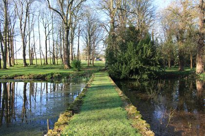
Our ecology surveys in Shrewsbury are studies of the plants and animals in a specific area. This includes their interactions with each other and their habitat. An ecology survey is carried out by qualified professionals, such as ourselves, to create an inventory of the living organisms and ecological features in a particular area. The purpose of an ecology survey is to understand the dynamics of the ecosystem and to identify any potential impacts, risks or constraints of a development on the landscape and species living within it. This is to assist developers and the local planning authority in establishing what the next steps are to mitigate the impact on the environment.
What type of Ecology Survey do I need?
There are a range of surveys available, each is suited to a different scenario. They assess the impact that a development project may have on the surrounding environment and go into varying depths of detail depending upon the type of survey that you have.
Ecology surveys in Shrewsbury that ProHort Ltd can provide include but are not exclusive to the following:
Preliminary Ecological Assessment (previously called the Phase 1 Habitat).
Phase 1 Ecology Survey.
Phase 1 Extended Survey including Protected Species – Bats, Birds and Mammals.
Biodiversity Net Gain Assessments including DEFRA.
How do I book my Ecology Survey?
Firstly, contact ProHort, we can provide you with a written quote for the ecology surveys in Shrewsbury that you require. Upon the confirmation that you would like to proceed, our specialist ecology consultant will visit the site to carry out the survey or assessment.
Once the survey has been completed, our consultant will put together your documentation. This will clearly show the results from the survey. This documentation will be sent in the form of a PDF or a physical copy of the report, if required.
To find out more about how ProHort can help you with your ecology surveys in Shrewsbury get in touch with us by calling 01782 479 479 or email us at [email protected].
Benefits and Disadvantages of Drone Surveying
In today’s rapidly evolving technological society, drones have altered various industries for the better. However, when it comes to drone surveying is there more pros or cons?
Benefits of Drone Surveying:
Faster data collection compared to traditional methods.
Improved safety as a result of removing humans from potentially hazardous situations.
Increased accuracy.
Realtime monitoring.
Cost effective in the long run, although has high initial investment costs.
Drawbacks of Drone Surveying:
Cost Implications:
Firstly, the initial cost of drone technology is expensive. It can cost thousands of pounds to buy a drone equipped with the cameras and sensors needed for drone surveying. On top of this there may be an additional need for accessories and software to enhance the drones functionality.
Maintenance costs also need to be considered as regular repairs, services, software updates and part replacements may be needed to keep the drone in optimal condition. All of the above need to be carried out by a professional and add to the overall operation cost of the drone.
In addition, drone pilots need to undertake expert training in order to operate a drone legally and safely. This training and certification come at a cost and is an ongoing expense as continuous professional development is necessary to maintain your certification.
Legal Requirements:
Drone surveying is subject to regulations set by the Civil Aviation Authorities (CAA). Commercial drones used for drone surveying need to be registered with the CAA and this needs to be renewed each year. The registration is of you as the operator rather than the drone. You can register, get your flyer ID and find more information at register-drones.caa.co.uk.
Furthermore, there are several privacy concerns that need to be considered. Failure to navigate the issues can result in hefty fines, legal repercussions and privacy violations. Drones that are equipped with cameras can take videos, images and collect data from private properties and individuals without their consent which has resulted in numerous lawsuits for alleged privacy violations.
Airspace Limitations:
Adhering to and understanding these airspace limitations is critical for drone operators. Drones are often restricted in certain areas such as airports, military bases and other sensitive locations. Additionally specific locations may be ”no-flight” zones due to safety or environmental concerns. You should never fly more than 120m (400ft) above the surface and always keep it in your site, taking extra caution in built up areas. Temporary airspace restrictions are frequently put in place across the UK, therefore you should check airspace information section before flying.
Weather Setbacks:
As we know, the UK is often subject to poor weather. This can be a disadvantage when drone surveying as strong winds and rain can limit the use of drones and can therefore delay data collection.
Fly Time:
The majority of drones have a limited flying time of approximately 15 to 30 minutes, therefore multiple flights may be required to complete surveys of large areas, resulting in prolonged survey times.
Contact Us:
At ProHort we understand the implications drones can have on wildlife and avoid drone use where possible. Get in touch with us now to discuss how we can help you with your planning needs.
Alternatively, you can find out more about the services we offer here.
Why not check out our Facebook page and connect with us on Linkedin?
Further to our previous article regarding Biodiversity Net Gain, on the 18th January 2024 it was announced that Biodiversity net gain assessments will be required from the 12th February 2024 (major developments) and from April 2nd 2024 (small developments). From these dates onwards, Biodiversity net gain assessments will be mandatory for new planning applications submitted for both major and small developments.
As defined by the Land Use Policy team, major developments include:
– Residential developments that include 10 or more dwellings.
– Developments where the site area is greater than 0.5 hectares.
Whereas smaller development projects will be subject to the mandatory Biodiversity net gain requirements from the 2nd April 2024.
A small site development has been defined as:
– Residential developments consisting of 1 – 9 dwellings.
– Residential developments where the site area if less than 0.5 hectares.
– Commercial developments where the floor space that is being created is less than 1000
square metres.
– Commercial developments where the total site area is less than 1 hectare.
Biodiversity Net Gain will be required for nearly all new applications for planning permission, however there are some exclusions.
These exclusions include:
– Requests for retrospective planning permission.
– Planning applications submitted prior to the 12th February 2024.
– Any applications to vary a planning condition on planning permission granted before the 12th February.
– Development works that do not impact a priority habitat and impacts less than 25 square metres of non-priority habitat. Alternatively, the development works should not impact more than 5 metres of non-priority linear habitat.
– The development of an existing property, except to change its use or change the number of dwellings within the property.
– Small scale self-build projects that consist of no more than 9 dwellings, are carried out on a site which is no larger than 0.5 hectares and consist exclusively of dwellings that are self-built.
– Development upon biodiversity gain sites, which are designed solely to enhance the biodiversity on behalf of other development sites, or provide access to the public for educational or recreational purposes without charging a fee.
– Development which is part of or ancillary to the High-Speed Transport Network.
Contact Us for Biodiversity Net Gain Assessments:
If you are a Developer or require a Biodiversity Net Gain assessment to accompany your planning application, ProHort can help! Get in touch with us now to discuss how we can help you and arrange your assessment.
Alternatively, you can find out more about the services we offer here.
Why not check out our Facebook page and connect with us on Linkedin?
This involves us creating a plan of any and all trees both on and off the site that could be affected by the construction of the new project. This is different to a Tree protection plan which only identifies trees that can be impacted by the build itself. The Construction Exclusion Zone report and survey identifies trees that would be impacted, for example, at the entrance of the site or even along the roadway which may be 50m or more from the new build.
The objective is to protect all the trees that may be potentially damaged or even have a small element of risk of being damaged during the construction phase. The risk may come from delivery lorries, parking of construction traffic, storage of materials within the root zone areas, chemical and diesel spills etc.
Planning officers sometimes request these documents as part of the Tree survey pack after the tree survey has been submitted. We find this is a significant factor in delaying planning and as such we would recommend supplying this report as a standard with the objective of ensuring the planning for your project is not delayed.
Next Steps...
Please give us a ring on 01782 479479 (Head office) or get in contact with us get in contact with us to discuss your project with you in detail to ensure we know exactly what you require, as well as what the Local Planning Authority have requested.
We will then be able to give you a quote for the work and as soon as you have paid the site survey is then booked in. Typically we conduct all site surveys within 2 working days and all reports are completed within two days of the survey.
We aim to provide great customer service which is why we have so many repeat clients. We look forward to speaking to you!
Why not follow us on Facebook to stay up to date with our latest news.